Key Product Capabilities
Interactive Space Simulations
Visualize the complex, ever changing dynamics of the sun-earth picture in a dynamical and interactive environment.
Coordinate System Flexibility
Get data in your coordinate system via our proprietary coordinate transformation cloud platform.
Enhanced Drag Modeling
Fly your satellites through a real-time first principles physics model to estimate drag and enhance station keeping capability.
Real-Time Atmospheric Density Data
Access a continuously updated nowcast of Earth’s total atmospheric density updated every 10 minutes.
our capabilities
Lorem ipsum dolor sit amet, consectetur adipiscing elit. Etiam quisfinibus purus. Mauris facilisis, sapien et sodales sollicitudin, dolor lacus venenatis turpis, vitae lacinia nunc mauris sed orci. Vivamus id ante cursus turpis imperdiet haretra id ut massa. Aliquam diam libero, sollicitudin non nisl eu, sollicitudin eleifend elit. Aliquam condimentum ligula ut lectus posuere lacinia. Morbi aliquam eget ipsum ac vehicula.
Vestibulum dapibus nisi pulvinar est vulputate, id blandit ligula blandit. Nullam in metus eu justo vestibulum dignissim. Cras consequat, lorem sit amet aliquam ullamcorper, tellus est lobortis neque, vitae blandit ex velit ac ex. Nunc lacinia auctor purus sed maximus. Cras in enim urna. Nulla molestie ipsum sed sollicitudin consequat. Etiam non posuere diam. Aliquam dignissim mollis

Current Products
Get Real-time Space Weather Data notifications. Customized to your enterprise needs.
Satellite Drag Explorer
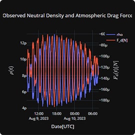
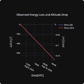
A dashboard flying a Starlink satellite through the Coupled Thermosphere Ionosphere Plasmasphere Electrodynamics Model (CTIPe) to compute local trajectory drag force.
read moreReal-Time Atmospheric Density API
A data delivery service generating continuous nowcasts of Earth’s total atmospheric density in low earth orbit.
read more
Satellite Drag Explorer
Ensemble's Satellite Drag Explorer flies satellite trajectories through a first-principles near real-time atmospheric physics-model: OAA's Coupled Thermosphere Ionosphere Plasmasphere Electrodynamics Model(CTIPe). This enables users to better assess and understand the local drag orce and estimated loss of altitudes for their satellite constellation in order to improve station-keeping capabilities.
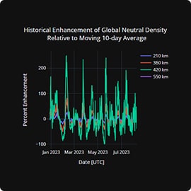
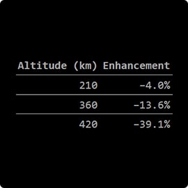
Enhancement of Global Neutral Density Relative to Mean over Previous 10 Days
Atmospheric Density API
About this API
Ensemble’s Atmospheric Density API delivers data files representing a continuously updated nowcast of Earth’s total atmospheric density, generating a nowcast file every 10 minutes.
- The API generates total atmospheric density in kg/m^3 as a function of longitude, latitude and partial pressure (instead of altitude).
- The API is designed to easily facilitate satellite trajectory model flythroughs as a near real time solution to calculate the local ionospheric drag of satellites in LEO and MEO.
- The model runs about 20 minutes ahead of real-time and nowcast files become accessible every 10 minutes.
- The API provides model density on a geographic longitude, latitude, altitude grid in a series of timestamped parquet files Example output grid: (rho(lon, lat, alt) The filename includes the date and time in ISO format.
- The API uses NOAA’s Coupled Thermosphere Ionosphere Plasmasphere Electrodynamics Model (CTIPe) currently hosted on the Integrated Space Weather Framework (ISWA) within the Architecture for Collaborative Evaluation (ACE) compute environment
The API converts raw model output to partial pressure using Kamodo’s function composition and coordinate transformation space physics-as-a-service Analysis Suite.
Authentication
To use the endpoint you need to authenticate your self via passing the api-key in header showing below. To get the api-key mail us at ogerland@ensembleconsultancy.com.

data access
base endpoint
https://32m1ggsea. execute-api. us-east-1.azazonows.cars/v1
list files
https://32meggs0a.execute-api-us-east-1.amazonaws contivlictipe-data
download files
/{bucket}/{file}GETX-API-KeyAPI_KEYSThe API uses NOAA’s Coupled Thermosphere Ionosphere Plasmasphere Electrodynamics Model (CTIPe) currently hosted on the Integrated Space Weather Framework within the Architecture for Collaborative Evaluation (ACE) environment, a shared compute eco-system between the Community Coordinated Modeling Center (CCMC) at NASA and the Space Weather Prediction Testbed (SWPT) at NOAA.
http://ccmc-swpc.s3-website-us-east-1.amazonaws.com/about.html
This is the second item’s accordion body. It is hidden by default, until the collapse plugin adds the appropriate classes that we use to style each element. These classes control the overall appearance, as well as the showing and hiding via CSS transitions. You can modify any of this with custom CSS or overriding our default variables. It’s also worth noting that just about any HTML can go within the .accordion-body, though the transition does limit overflow.
This is the third item’s accordion body. It is hidden by default, until the collapse plugin adds the appropriate classes that we use to style each element. These classes control the overall appearance, as well as the showing and hiding via CSS transitions. You can modify any of this with custom CSS or overriding our default variables. It’s also worth noting that just about any HTML can go within the .accordion-body, though the transition does limit overflow.
This is the third item’s accordion body. It is hidden by default, until the collapse plugin adds the appropriate classes that we use to style each element. These classes control the overall appearance, as well as the showing and hiding via CSS transitions. You can modify any of this with custom CSS or overriding our default variables. It’s also worth noting that just about any HTML can go within the .accordion-body, though the transition does limit overflow.
